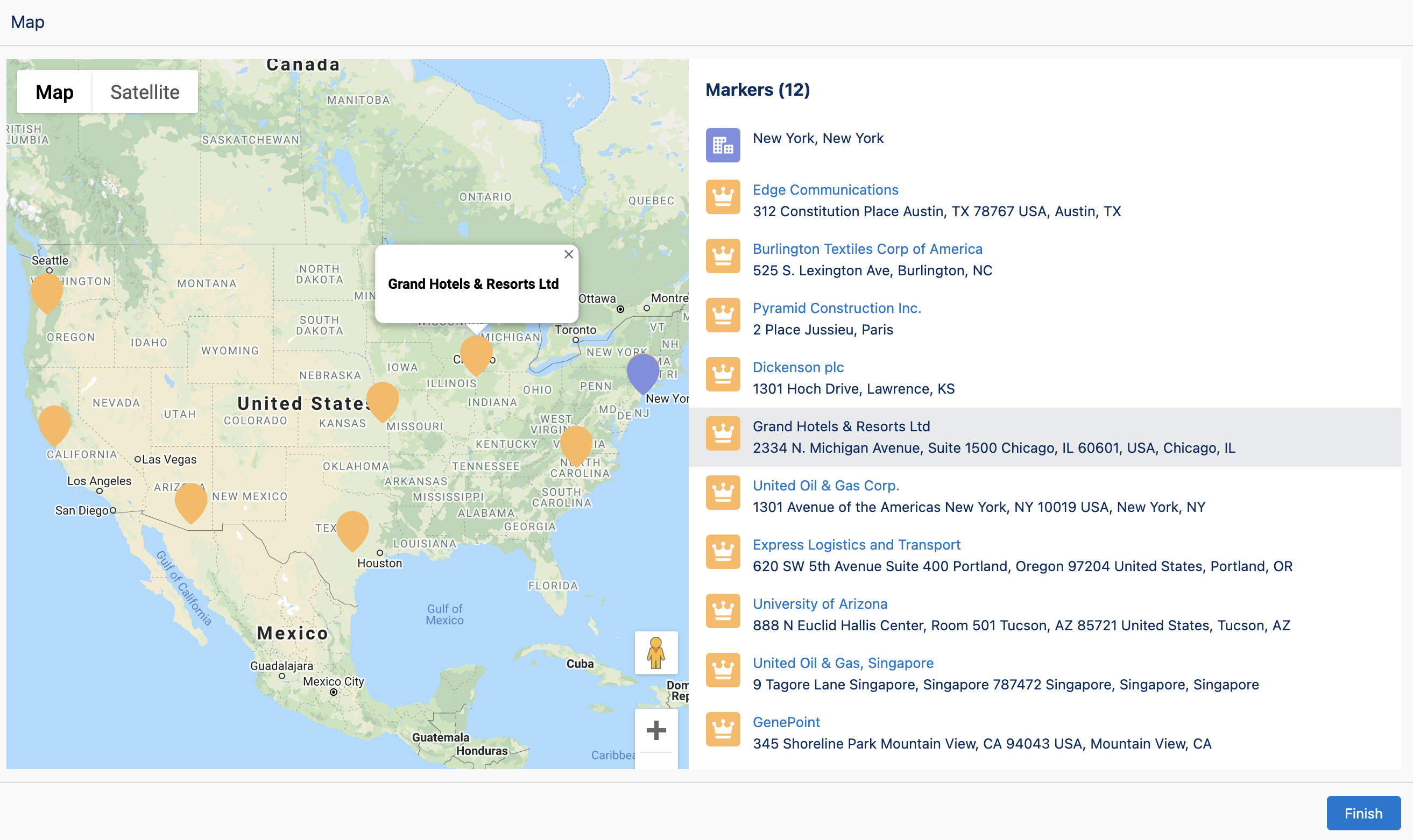
Map: Display Records
Overview
The Map: Display Records component displays a collection of records on a map. A center marker in a different color can also be displayed on the map. This is useful for designating the center marker in one color and surrounding markers in a different color.

Records Configuration Inputs
Records Object Type
Object type if using the records input to map a collection of records. If not using this input, select any object and ignore.
Records
A collection of records to map. Ensure these records have address fields or latitude and longitude fields populated.
| Type |
|---|
| Record Collection |
Title Field API Name
The api name of the Title field on the object in the records collection. This is displayed in the map marker tooltip and list.
| Type |
|---|
| Text |
Description Field API Name
The api name of the Description field on the object in the records collection. This is displayed in the map marker tooltip.
| Type |
|---|
| Text |
Latitude Field API Name
The api name of the Latitude field on the object in the records collection.
| Type |
|---|
| Text |
Longitude Field API Name
The api name of the Longitude field on the object in the records collection.
| Type |
|---|
| Text |
Street Field API Name
The api name of the Street field on the object in the records collection.
| Type |
|---|
| Text |
City Field API Name
The api name of the City field on the object in the records collection.
| Type |
|---|
| Text |
Postal Code Field API Name
The api name of the Postal Code field on the object in the records collection.
| Type |
|---|
| Text |
Country Field API Name
The api name of the Country field on the object in the records collection.
| Type |
|---|
| Text |
Marker Color
Hexadecimal CSS value to set the color of the map markers in the records collection, or a JSON string for dynamic color mapping based on field values.
Static Color Example:
#ea001e
Dynamic Color Example:
{
  "field": "Industry",
  "default": "#cccccc",
  "values": {
    "Aerospace": "#1f77b4",
    "Automotive": "#ff7f0e",
    "Banking": "#2ca02c",
    "Education": "#d62728",
    "Healthcare": "#9467bd"
  }
}
When using dynamic colors:
field: The API name of the field to use for color mapping (case-insensitive)values: An object mapping field values to hex color codes (case-insensitive matching)default: Optional hex color code for records with field values not in the mapping (defaults to#ccccccif not specified)
| Type |
|---|
| Text |
Marker List Icon
The Lightning Design System name of the icon to display in the list of markers in the records collection. Names are written in the format 'utility:down' where 'utility' is the category, and 'down' is the specific icon to be displayed Examples: 'action:approval', 'utility:chart', 'doctype:image', 'standard:account', 'custom:custom33'
| Type |
|---|
| Text |
Center Marker Configuration Inputs
Center Marker Title
The title value of the center marker. This is displayed in the center map marker tooltip and list.
| Type |
|---|
| Text |
Center Marker Description
The description value of the center marker. This is displayed in the center map marker tooltip.
| Type |
|---|
| Text |
Center Marker Latitude
The latitude value of the center marker.
| Type |
|---|
| Number |
Center Marker Longitude
The longitude value of the center marker.
| Type |
|---|
| Number |
Center Marker Street
The street value of the center marker.
| Type |
|---|
| Text |
Center Marker City
The city value of the center marker.
| Type |
|---|
| Text |
Center Marker State
The state value of the center marker.
| Type |
|---|
| Text |
Center Marker Postal Code
The postal code value of the center marker.
| Type |
|---|
| Text |
Center Marker Country
The title value of the center marker.
| Type |
|---|
| Text |
Center Marker Color
Hexidecimal css value to set the color of the center map marker. Example: #ea001e
| Type |
|---|
| Text |
Center Marker List Icon
The Lightning Design System name of the icon to display in the list for the center marker. Names are written in the format 'utility:down' where 'utility' is the category, and 'down' is the specific icon to be displayed. Examples: 'action:approval', 'utility:chart', 'doctype:image', 'standard:account', 'custom:custom33'
| Type |
|---|
| Text |
Map Configuration Inputs
List View Visibility
Controls the behavior of the list view. Valid values are 'visible', 'hidden', or 'auto'. This value defaults to 'hidden'. 'auto' shows the list only when multiple markers are present."
| Type | Valid Values |
|---|---|
| Text | hidden (default), visible, auto |
List Title
The title for the list of markers when it is visible.
| Type |
|---|
| Text |
Height (Max)
Sets the maximum height of the map in pixels. The map scales smaller based on the screen size but will not exceed the height in pixels set by this input.
| Type |
|---|
| Text |
Height (Fixed)
Sets the fixed height of the map in pixels. This input overrides Height (Max) if both are set.
| Type |
|---|
| Text |
Configuration Outputs
Selected Record
Set when a user selects a marker on the map or a record in the list.
| Type | Variable Name |
|---|---|
| Record | selectedRecord |